The complete Girivalam route map with every landmark on the 14 km Arunachala path — Ashta Lingams, ashrams, theerthams, rest stops and insider walking tips.
The Girivalam route map is the single most useful thing you can carry — mentally or on your phone — before you walk the 14 km sacred path around Arunachala Hill in Tiruvannamalai. Most first-time pilgrims start full of devotion and end up confused around the third kilometre, missing half the lingams because nobody told them what to look for. This guide fixes that. Below you will find every landmark in walking order, with realistic distances, exact directions, and the small but crucial details that experienced devotees know — which lingam sits hidden between two houses, where the path narrows, and why one stretch is darker than the rest.
Quick Summary: What the Girivalam Route Map Covers
Before getting into the detailed walk, here is what most pilgrims ask about upfront. This snapshot answers the basics so you can plan the rest with confidence.
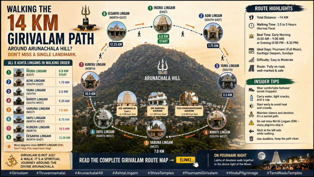
- Total distance: Approximately 14 km (8.7 miles) in a clockwise loop
- Starting point: Sri Arunachaleswarar Temple, East Raja Gopuram
- Walking time: 3 to 5 hours at a steady pace
- Direction rule: Always keep Arunachala Hill on your right
- Ashta Lingam order: Indra → Agni → Yama → Niruthi → Varuna → Vayu → Kubera → Eesanya
- Best months: December to February (cool weather, clear hill views)
- Major landmarks: 8 Ashta Lingams, 3 main ashrams, Adi Annamalai Temple, several theerthams
Understanding the Girivalam Route Map and Its Sacred Geometry
The Girivalam route map is not a random walking trail. Notably, it forms a near-perfect octagonal loop around Arunachala, with the eight Ashta Lingams placed exactly at the eight cardinal and inter-cardinal directions. This is intentional — ancient builders aligned each shrine with a specific direction and a specific planet.
The 14 km figure carries its own meaning. According to traditional belief, the distance symbolises the 14 Lokas (worlds) of Hindu cosmology. Walking the full circuit is therefore considered a journey through every realm of existence. According to Wikipedia, the eight shrines are also linked to the twelve moon signs in traditional astrology.
However, the path is not flat. The road dips and rises gently, with the hill always to your right. Therefore, when you feel the slope on your left calf rather than your right, you have lost direction — turn back and check.
Why the Route Goes Clockwise (and Why It Matters)
Hindu pradakshina tradition always moves clockwise around a deity, with the right side facing the sacred object. Since Arunachala itself is the deity here — a Swayambhu Linga, or self-manifested Shiva — the same rule applies on a massive scale. Walking anti-clockwise is considered inauspicious. Moreover, the route signage and crowd flow on Pournami nights all assume clockwise motion.
Starting Point: Arunachaleswarar Temple to Indra Lingam
Every Girivalam route map begins at the Sri Arunachaleswarar Temple in central Tiruvannamalai. Specifically, devotees enter through the East Raja Gopuram — the towering 11-storey, 217-foot gateway built by King Krishna Devaraya of the Vijayanagar empire and completed by Sevappa Nayaka of Thanjavur.
Before stepping onto the path, tradition asks you to do three quick things. First, take darshan of Lord Annamalaiyar inside the main sanctum. Second, seek permission from Bootha Narayana Swami, the guardian deity of Tiruvannamalai. Then, worship the Rettai Pillaiyar (twin Ganesha) shrine just outside the temple. Only after this is the Girivalam considered properly begun.
From the East gate, walk north along Car Street, then turn left onto Chengam Road. Within roughly 800 metres you reach the first major landmark.
Stop 1: Indra Lingam (East — 1.5 km mark)
Indra Lingam is the first of the Ashta Lingams. Notably, it sits on the eastern face of Arunachala and represents Lord Indra, king of the celestial gods. The dominant graham (planet) here is Surya (Sun) along with Sukran (Venus). Pilgrims pray here for long life, leadership, and material prosperity.
Right next to the shrine is the Indra Theertham — a sacred tank — and the Indra Mandapam, where many devotees pause for the first rest. Furthermore, this stretch is well-lit and lined with shops selling water, flowers, and camphor.
Girivalam Route Map: Detailed Landmark Sequence
The next segments follow the road as it curves south. Here the route map gets denser — there are several smaller temples, theerthams, and ashrams between the main lingams. Below is the full walking sequence.
Stop 2: Sri Ramana Ashram and Sri Seshadri Swamigal Ashram (2 km mark)
Around 1.5 km from the main temple on Chengam Road, you arrive at two adjacent ashrams that draw seekers from every continent. Sri Ramanasramam houses the samadhi of Sri Ramana Maharshi, the great Advaita sage who lived at Arunachala for 54 years. The hill darshan from inside the ashram is called Eru Pancha Mukha Darshan.
Right beside it stands Sri Seshadri Swamigal Ashramam, located at Thamarai Nagar Main Road. The ashram is famous for its meditation hall and its modest canteen, which serves simple South Indian meals at nominal prices throughout the day. Furthermore, Seshadri Swami is historically remembered for protecting the young Ramana Maharshi during his early days at the Patala Lingam.
Stop 3: Karpaga Vinayaka Temple and Simha Theertham
About 500 metres further, the Karpaga Vinayaka Ganesh temple appears on the route. Tradition says you should worship Lord Ganesha here for obstacle removal before continuing. Just past it lies the Simha Theertham — a sacred tank associated with Yama Lingam.
Stop 4: Agni Lingam (Southeast — 2.5 km mark)
Agni Lingam is the second Ashta Lingam and the only one positioned on the right side of the path. Specifically, it faces southeast, and devotees believe Lord Agni himself installed it. The dominant planet is Chandra (Moon).
The shrine is small and tucked between residential houses, with only a modest arch indicating its presence. Many first-time walkers miss it entirely. Therefore, slow down around the 2.5 km mark and watch the right side carefully. Pray here for freedom from disease and the strength to face life’s struggles.
Stop 5: Yama Lingam (South — 3.5 km mark)
The third Ashta Lingam stands close to the cremation grounds along Chengam Road. Yama Lingam represents the south direction, and Yama himself — the god of death — is said to have installed it. The dominant graham is Sevvai (Mars).
Worshipping here is believed to relieve financial constraints and grant longevity. Although the location near the cremation ground unsettles some pilgrims, devotees say it is precisely this confrontation with mortality that gives the lingam its power.
Stop 6: Niruthi Lingam (Southwest — 5 km mark)
Continuing south-west, you reach the fourth lingam. Niruthi Lingam is dedicated to Niruthi, the king of asuras who jointly rules the southern realm with Yama. The dominant graham is Rahu, and the shrine has its own holy tank — the Sani Theertham.
Devotees worship here for protection from negative influences, evil spirits, and persistent obstacles. Naturally, this stretch of the route map is also where the road begins to feel quieter — fewer shops, fewer streetlights at night.
Stop 7: Adi Annamalai Temple (6 km mark — Western Side)
Adi Annamalai is one of the most ancient temples on the entire route. Importantly, it is dedicated to Lord Shiva and is considered older than the main Arunachaleswarar Temple itself. The temple sits in Adi Annamalai village on the western side of the hill, and the address is Girivalam Road, Adi Annamalai, Tamil Nadu 606604.
Many devotees consider darshan at Adi Annamalai non-negotiable. The temple offers a unique view of Arunachala from its rear, and the inner sanctum carries an unusual stillness even on Pournami nights.
Stop 8: Varuna Lingam (West — 7 km mark)
Roughly one kilometre before Adi Annamalai village, on the outer Girivalam path, lies the fifth Ashta Lingam. Varuna Lingam represents the west and is associated with the god of rain. The dominant planet is Sani (Saturn), and the Varuna Theertham flanks the shrine.
Pilgrims pray here to wash away accumulated sins and to seek protection from water-related illness. Additionally, the lingam is believed to support social standing and reputation.
Stop 9: Vayu Lingam (Northwest — 8.5 km mark)
About one kilometre after Adi Annamalai village comes the sixth Ashta Lingam. Vayu Lingam faces northwest and is said to have been installed by Vayu Bhagavan, the god of wind. The dominant graham is Ketu.
The associated darshan is called Kanda Neeru Mukha Darshan. Worship here is believed to relieve heart problems, lung issues, stomach ailments, and respiratory illnesses. Notably, just past Vayu Lingam stands a Nandi figure whose horns frame a unique hill view called Janma Saabalya Mukha Darshan — said to release one from inherited curses.
Stop 10: Abhaya Mandapam (9 km mark)
A small mandapam appears next on the route. The hill darshan from here is the Dasa Mukha Darshan — a vision believed to have helped even the demon Ravana find redemption from his sins.
Stop 11: Kubera Lingam (North — 10 km mark)
The seventh Ashta Lingam stands a few hundred metres before the Panchamukham area, just before the route re-enters the town. Kubera Lingam faces north, and the dominant graham is Guru (Jupiter).
Lord Kubera, the divine treasurer, distributes wealth rather than creating it. Therefore, devotees pray here not for sudden riches but for stable prosperity, fair earnings, and successful enterprises.
Stop 12: Yogi Ramsuratkumar Ashram (11 km mark)
Yogi Ramsuratkumar Ashram sits at Agraharakollai, 1833/1 Chengam Road, TSR Nagar, Tiruvannamalai 606003 — about 2.5 km from the main Arunachaleswarar Temple, which means roughly 11 km along the Girivalam loop. The ashram houses the samadhi of Yogi Ramsuratkumar (1918–2001), known affectionately as the “Visiri Saamiyar.”
The ashram offers free short-stay accommodation (typically under a week) and a famous lunch service between 11 AM and 1 PM, open to all walkers. Voluntary contributions are accepted but never demanded.
Stop 13: Eesanya Lingam (Northeast — 12.5 km mark)
The eighth and final Ashta Lingam sits on the old Girivalam road back into town, beside the main cremation grounds. Eesanya Lingam faces northeast, the most auspicious direction, and the dominant graham is Budhan (Mercury).
Worship here is believed to grant peace of mind, mental clarity, and spiritual upliftment. Furthermore, completing the eighth lingam closes the cosmic circle of the eight directions — a moment many pilgrims describe as the most powerful of the entire walk.
Stop 14: Bootha Narayana and Rettai Pillaiyar (Closing 13.5 km)
As you approach the East Raja Gopuram, the route map ends where it began. Tradition says to revisit Bootha Narayana Perumal and Rettai Pillaiyar — both temples sit very close to each other near the East Tower — to formally conclude the Girivalam.
Girivalam Route Map: Distance Summary Table
| Landmark | Approx. KM | Direction |
|---|---|---|
| Arunachaleswarar Temple (Start) | 0 km | — |
| Indra Lingam | 1.5 km | East |
| Sri Ramana Ashram | 2 km | East-Southeast |
| Agni Lingam | 2.5 km | Southeast |
| Yama Lingam | 3.5 km | South |
| Niruthi Lingam | 5 km | Southwest |
| Adi Annamalai Temple | 6 km | West |
| Varuna Lingam | 7 km | West |
| Vayu Lingam | 8.5 km | Northwest |
| Abhaya Mandapam | 9 km | North-Northwest |
| Kubera Lingam | 10 km | North |
| Yogi Ramsuratkumar Ashram | 11 km | Northeast |
| Eesanya Lingam | 12.5 km | Northeast |
| Return to Temple | 14 km | — |
Insider Tips for Walking the Girivalam Route Map
Most online guides give the same generic advice — wear comfortable clothes, carry water, walk barefoot. However, after speaking to regulars and observing how Pournami nights actually unfold, a few practical points stand out.
Time Your Start Carefully
On Pournami nights, the crowd peaks between 8 PM and 11 PM. Therefore, starting around 5 PM gets you ahead of the wave and lets you reach Adi Annamalai before darkness deepens. Conversely, starting after midnight gives you a quieter, cooler walk — though some segments are dimly lit.
Watch the Outer vs Inner Path
The Girivalam path forks in places between an inner road (closer to the hill, slightly shorter) and an outer road (longer, with a few extra shrines). Most pilgrims unknowingly switch between the two. Specifically, Varuna Lingam sits on the outer path — if you stay strictly inner, you will miss it.
Barefoot or Sandals?
Tradition asks for bare feet. However, the road surface is hot tar in summer and often littered with small stones near unlit stretches. Many regular walkers now carry thin cloth socks or wear them for the first 7 km and remove them on the spiritually denser second half.
Carry Minimal but Smart
A small bottle of water, a flashlight or phone torch, ₹100–200 in small denominations for offerings and tea, and a clean cotton handkerchief are usually enough. Importantly, leave valuables behind — you will not need them, and crowded sections invite carelessness.
Best Time to Walk the Route — A Realistic View
The most popular days are Pournami (Full Moon), Karthigai Deepam (November–December), and Maha Shivaratri. Tamil Nadu Tourism notes that Karthigai Deepam draws between 1 million and 1.6 million pilgrims in a single night.
For a peaceful first experience, however, avoid the festival rush. December and January offer cool weather, clear hill views, and manageable crowds on non-Pournami days. Conversely, April to June can be punishing — the road radiates heat well past sunset.
What’s Changing on the Girivalam Path
Two trends are shaping the future of this pilgrimage. First, the central government has, through the Supreme Court, asked Tamil Nadu to formally protect the Girivalam path under the proposed Tamil Nadu Heritage Conservation Act. If implemented, this could limit unregulated construction along the route.
Second, traffic management on Pournami nights has tightened. Police now divert vehicles further from the inner path, which has improved walker safety but added confusion for first-time visitors arriving by car. Therefore, parking near the route on full moon days is best done before 4 PM.
Final Thoughts
The Girivalam route map is more than a list of stops — it is an ancient navigation system designed to move you through eight directions, eight planets, and a sequence of ever-deepening hill darshans. Walk it once with this map in mind, and the second walk becomes entirely different. The first time you notice the path. The second time you notice yourself. For most walkers, that second walk is when the meaning of pradakshina finally lands.
Frequently Asked Questions
How long does it take to complete the Girivalam route map?
Most pilgrims complete the 14 km Girivalam route map in 3 to 5 hours at a steady walking pace. However, if you stop at every Ashta Lingam, ashram, and theertham, the walk can stretch to 6 or 7 hours. Slow walkers and elderly devotees often split the route across two days.
Can I walk the Girivalam route any day, or only on Pournami?
You can walk it any day of the year. Although Pournami (Full Moon) is considered the most spiritually charged time, the path is open and active 365 days a year. Many regular devotees specifically avoid Pournami to enjoy a quieter, more meditative walk.
Is the Girivalam route map safe for solo walkers at night?
Yes, especially on Pournami and festival nights when thousands walk together and the route is well-lit and patrolled. On non-festival nights, the stretch between Niruthi Lingam and Adi Annamalai can feel isolated. Therefore, solo walkers usually prefer dawn or daylight hours on regular days.
Where exactly is the starting point of the Girivalam route?
The traditional starting point is the East Raja Gopuram of Sri Arunachaleswarar Temple in central Tiruvannamalai. Pilgrims first take darshan of Lord Annamalaiyar inside, then seek permission from Bootha Narayana and Rettai Pillaiyar before stepping onto Chengam Road.
Can children and elderly people complete the Girivalam route map?
Yes, with proper preparation. Children above 8 and reasonably mobile elderly devotees regularly complete the walk. Plan for extra rest stops every 2 km, carry water, and avoid peak afternoon heat. Some families also break the route across two consecutive days to manage fatigue.
Is there an entry fee or booking required for Girivalam?
No. The Girivalam route is completely free, and no booking is required. The path is a public road open to all devotees regardless of faith or nationality.